|
Collect Data Objects |

  
|
|
Collect Data Objects |
|
At this step in the workflow, you collect the data you want to use to build and interpret your conceptual model.
The conceptual modeling workflow is data driven. This means that you first need to "collect" the appropriate data objects in order to use these at a particular step in the workflow. Data objects can be "collected" through several means:
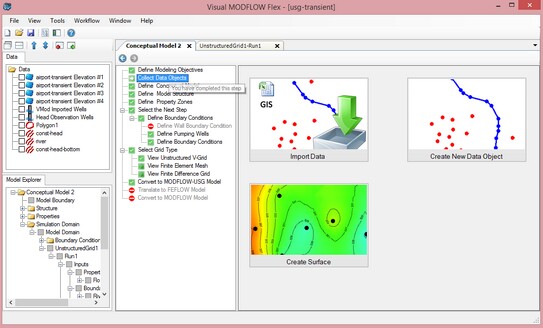
| Ø | Importing Data : Import GIS data (shapefiles, CAD files), Gridded data, images, points/wells in excel spreadsheets, or XYZ points in text format. |
| Ø | Creating Data Objects: digitizing new point, polygon, or polyline data objects. |
| Ø | Creating Surfaces: Interpolate XYZ points using Krigging, Natural Neighbor, or Inverse Distance. The resulting surfaces can be used to define geological layers or 2D parameter distributions (Kx, Recharge, etc.) |
|
||||
In order to build your conceptual model, you require at least the following data objects:
|
Once you have the data loaded, Click ![]() (Next Step) to proceed.
(Next Step) to proceed.
You may return to this step in the workflow at any time during the model process to import or create new data objects.
See the following table for some typical data object types and how they are used in the conceptual model workflow.
If you have... |
First you should.. |
Then you can.. |
|---|---|---|
River locations in a shapefile |
Import these as Polyline data objects |
Select this data object when creating a river boundary condition |
Geological layers in a Surfer .GRD or ASCII GRD |
Import these as Surface data objects |
Select these data objects when defining horizons |
Air photo with river location |
Import this as a Map image Then Create a new Polyline data object Digitize the polyline in a 2D Viewer |
Select this new polyline data object when creating a river boundary condition |
XYZ points for geological contacts |
Import these as Points data objects Then "Create Surfaces" from these data objects |
Select these surfaces when defining horizons or numerical model layers |
Raster Grid of Kx or Recharge data (from Surfer, ESRI .GRD) |
Import these as surface data objects |
Select these data objects when defining properties or Recharge boundary conditions |