|
Define Zone Budget Zones |

  
|
|
Define Zone Budget Zones |
|
ZoneBudget is a USGS program for computing subregional water budgets for MODFLOW ground-water flow models. Within Visual MODFLOW Flex, you can create new zones for MODFLOW-2000 and -2005 models in the numerical model workflows. If you imported a Visual MODFLOW classic model, you can also view the zone budget zones that were defined in this numerical model.
At the Define Zone Budget Zones step, you can create new zone budget zones using 2D/3D point, polyline, or polygon shape objects from the Data tree, and digitize new zones using Assign Polyline, Polygon, or Point (Single Cell)
|
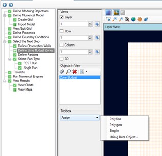
Follow the steps below to create new zone budget zones:
| · | [Assign >] Polyline. Use the left mouse button to start digitizing a polyline over the desired cells. Once you have finished digitizing, click on the Finish button from the toolbox, or right click with the mouse and select "Define Attributes". The following window will appear |
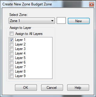
| · | Click the New button to assign the selected cells to a New zone; otherwise, you can select to assign cells to an existing zone by selecting the zone from the dropdown list at the top. The selected cells can be assigned to the current layer or multiple layers using the check boxes at the bottom of the window. Once you are finished, click OK. |
.
| · | [Assign >] Polygon: Digitize one or more polygons, and repeat the steps as described above for Assign > Polyline. |
| · | [Assign >] Single: Left-click on one or more cells and a point will appear. Once finished, right-click and select "Define Attributes", and follow the steps as described above for Assign > Polyline. |
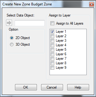
| · | Choose the desired point, polyline, or polygon data object from the tree. |
| · | Click on the |
| · | Select the desired model layers where the zone should be applied. |
| · | Note: if you choose a 2D shape object (where elevation value is 0), then the zone budget will be created only in the selected layer(s); if you select a 3D shape, then the elevation value from the shape object will be used to calculate intersecting cells from the appropriate layer, and create a zone in this appropriate layer(s) |
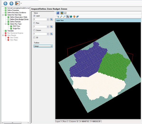
A simple example is shown below for a polygon data object (shown in red).
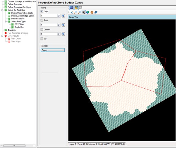
After the zones are generated, they will appear in layer view.
When the selected shape contains multiple polyline or polygon features, then a new zone will be created for each feature.
Zone Budget values can also be adjusted on a cell-by-cell basis by editing the values in a CSV file. For more details, see Define Properties